|
Some places of scientific interest in Lisbon
The esferas armilares, the compass rose, the Observatory in Ajuda and the clock in Cais do Sodré are some of the places in Lisbon which reveal a scientific history at times forgotten.
Those of us who pass through Lisbon every day are condemned to the fact that by knowing it so well some of the buildings and monuments are natural to us, as if they had always been there. This is probably the reason why there are certain curious details in the city that pass unnoticed to its residents. Let us take the esfera armilar, for example. All of us know it, not only from the national flag and from the five hundred escudos notes, but also from the reproductions in stone in the Jerónimos Monastry and in other buildings from the period of Manuel I, as well as from the models that are found a little everywhere.
|
 |
|
|
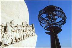
In Belém, flanking the Padrão dos Descobrimentos, are two metal structures, fine examples of the sphere of D. Manuel’s reign. What does this sphere represent? What do the horizontal arcs and the slanting band across it mean?
The esfera armilar is a mathematical model of the universe – as people used to say in those days, today the expression ‘geometrical model’ might be used –, based on the Ptolemaic conception of the cosmos. It was this model that enabled navigators to travel all over the globe and to be guided by the stars when crossing the oceans.
Aristotle and Ptolemy’s vision of the universe was, as in common knowledge, a geocentric vision: the Earth was placed motionless in the centre of the world, with the stars revolving around it. Today we know that this vision does not correspond to reality. However, in order to explain the apparent movement of the stars and for navigation by heights, which was based on looking at the sky, it is practically indifferent to consider the Earth in the centre of the world or to consider it revolving around the sun. Although the major polemics of Copernicus, Bruno, Kepler and Galileo have come to a close and all the emotion of these confrontations has died down, today we still speak of the movement of the sun, of Venus rising or of the constellations passing by. We know that we are speaking of apparent movements, yet we use a comfortable and intuitive language. At the time of the great journeys of discovery, it was more than a comfortable language. It was a belief in the reality of the universe and a belief that, as a geometrical and mathematical model, served the purposes of navigation perfectly.
The esfera armilar represents the cosmos. The large outer globe shows the celestial sphere; the small ball in the centre, the Earth. The sphere is shown via armilas or annulets, a word that means rings, bracelets or hoops and which gave rise to “amilar”. These rings indicate the main circles: the polar circles, the tropics, the meridians and the equator. It is the projection in the celestial sphere of corresponding circles marked on the earth globe. There is a further diagonal band which should have an inclination of 23.5º in relation to the equator, but which often has other inclinations for purely aesthetical reasons. This is the band of the zodiac, a band of more or less 8º around the ecliptic, the line representing the apparent movement of the sun across the sky and which passes through the so-called signs of the zodiac.
This band is slanted for the same reason that modern earth globes are slanted – because the Earth’s axis is 23.5% oblique in relation to the relocation plan. In modern earth globes, the Earth’s axis is diagonal and the supporting base is parallel to the ecliptic, which is in fact the project in space of the Earth’s relocation plan around the sun. In the esfera armilar, the north-south axis is normally vertical and it is the zodiac band that is oblique.
On the pavement in front of the Padrão dos Descobrimentos, visitors can view a beautiful map of the world as well as a gigantic compass rose, indicating the cardinal points. In days gone by, the compass roses had two, four, eight or twelve directions or winds. Later roses had 32 directions. This is not merely a symbol of the directions on a map.
When marine or navigational compasses started to be used by the Europeans, most probably in the thirteenth century, they already contained a ring that was attached to the magnetic needle where the compass rose was drawn. This ring was placed in a box that remained horizontal, without being affected by the swaying of the boat, by an axial system called “balance” later called “cardan”, in memory of the Italian Gerolamo Cardano (1501-1576), who later designed a similar device. The principle is very similar to that of the “cardans” connected to the wheels of automobiles, which enable them to move perpendicularly to the ground, despite the possibility of the axles becoming inclined.
 |
|
(click on the picture above to see an enlarged version)
|
|
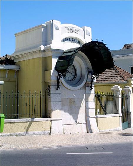
Another very well known object to the Lisbonners is the famous clock Relógio da Hora Legal in Cais do Sodré. It is seen so much that it is forgotten. However, the history of this instrument is very interesting. When the legal hour services were instituted at the beginning of the century, the clock was responsible for keeping the exact time and for serving as a reference to pilots who confirmed the state of their chronometers. Marine chronometers, vital for measuring longitude in the sea, are not set as common clocks are. What is important is to know their state, i.e. their difference in relation to the hour: mariners then subtract or add the minutes and seconds necessary.
The clock in Cais do Sodré was set daily based on the information received from the Astronomical Observatory in Ajuda for the Administration of the Harbour of Lisbon, with its headquarters on the corner of the riverside square. A line dedicated to the communication between the hour and the harbour services was created, however the system never worked well. The clock that remains there and testifies to those times had an irregular life. It was set right when in actual fact it was not wrong. In 1946, with the creation of the Permanent Hour Commission, which still exists today, the clock ceased to be a reference instrument.
Those who wish to get off the streets and visit public buildings have many places of scientific cultural interest to visit: the Academy of Sciences and the museums in the same building, the Museu da Marinha, the Pavilhão do Conhecimento and the Museu da Cidade, to mention only a few. We leave you with a final suggestion if you are passing by the Rua da Escola Politécnica.
|
 |
|
(click on the picture above to see an enlarged version)
|
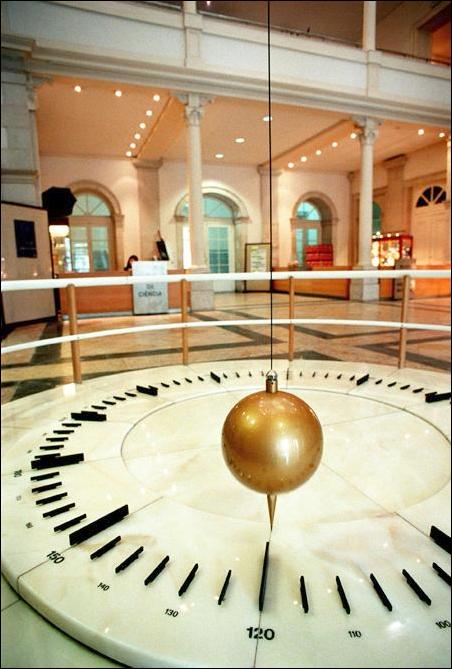
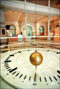
In the atrium of the Museu de Ciência, just before you to get to the reception, is a fine example of the Pêndulo de Foucault. This gigantic pendulum, similar in style to the one built in 1851 by the French astronomer Jean Bernard Leon Foucault (1819-1868) for the great exhibition in Paris. This device was the first piece of evidence of the movement of the Earth, showing that a pendulum left to swing will slowly change its plane of oscillation. If the pendulum is working, it will be interesting to visit it again a few hours later and to verify that this plane has moved. In truth, it is the Earth that moves under the pendulum, which tries to keep its plane of oscillation unchanged. At the poles, the Foucault pendulums describe a complete spinning motion in 24 hours – or better, it is the Earth that describes this movement. At the equator the plane of oscillation remains unchanged in relation to the ground. In Lisbon, which lies at an intermediate latitude of 38º, this movement in relation to the ground causes the pendulum to describe a complete rotation in approximately one and a half days. In the atrium of the Museu de Ciência, visitors see the Earth rotating under their feet.
Nuno Crato
|
|